A Field technician will arrive to the site with 3 different types of lasers as well as computer equipment. The technician then decides which laser will work best for each scenario within the project, i.e. interior, exterior, low light, direct sunlight, long expansive open areas, small congested areas etc. The technician then uses the appropriate laser (terrestrial or non terrestrial) to scan each area. This can take several hours to many days depending on the lasers best suited for the scans, the deliverables, as well as the size of the project.
A Field technician will arrive to the site with 3 different types of lasers as well as computer equipment. The technician then decides which laser will work best for each scenario within the project, i.e. interior, exterior, low light, direct sunlight, long expansive open areas, small congested areas etc. The technician then uses the appropriate laser (terrestrial or non terrestrial) to scan each area. This can take several hours to many days depending on the lasers best suited for the scans, the deliverables, as well as the size of the project.
After collecting all of the field LiDAR scans, the technician then uploads them to a computer where they are decompressed and checked for precision and clarity. This process can take anywhere from 6 hours to several days depending on the size of the project. Some project raw files can exceed 3 terabytes of information! It’s important to keep in mind lasers can take over of 750,000 measurements per second! Each measurement appears as a single colorized dot within the point cloud scan. Each dot is nothing more than a marker indicating x, y, and z coordinates for the corresponding measurement.
After reviewing the scans, the technician then decides if additional field visits will be necessary to acquire more scan data or rescans if an area did not pass quality control accuracy metrics. Once the technician is satisfied with the field data, it is transferred to a program where the data is combined one scan at a time then the combination is reviewed and registered.
When all scans are registered and combined, the point cloud is complete but must now be cleaned up with several hours of post processing prior to sending to the CAD modeling department. After post processing, the scan set is finalized and several reports are generated to ensure the scan set is accurate and all the math is proven to be within tolerance.
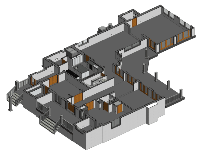
If the reporting is satisfactory, the scan set is now saved down to a point cloud that is useable to a modeling technician inside the REVIT platform. This deliverable in a RCP format is then sent to the modeling department. The modeling department now has a point cloud they can use to create a 3D model line for line and item for item. There is nearly nothing that is automated in this process and it takes a highly skilled technician with many years of Revit training using point cloud information to create your model. Now the modeling begins.
Once the model is complete, the entire process is checked once again to ensure the point cloud information is accurately represented in the model. After a complete audit of the entire process, the model is now ready for the client. They will receive the link to the model and the RCP point cloud it was generated from.